Introduction into Marine Spatial Planning
Marine Spatial Planning (MSP) is a long-term and strategic decision-making process that guides where and when human activities occur in the ocean. Making sure the right activity takes place in the right areas and helps facilitate the development of a sustainable blue economy – benefitting South Africans and the environment alike. The major MSP output is a comprehensive sustainable development plan that guides where and when uses occur in the ocean.
MSP in South Africa aims at:
- Unlocking the ocean economy
- Enabling society to engage with the ocean
- Ensuring a healthy marine ecosystem
- Good ocean governance
- Video – “Marine Spatial Planning (MSP) in a nutshell" in English, isiZulu and isiXhosa
Significance of MSP for South Africa
There is a growing range of industries in the South African ocean space. These need to be managed in a coordinated way, to avoid conflicts between marine uses and conflicts with the environment. South Africa is therefore implementing MSP to facilitate integrated management of human uses in the ocean.
Our ocean is one of South Africa's greatest assets that needs to be well managed in order to:
- Balance socio-economic development and ecological sustainability
- Provide security for public and private sector investment
- Encourage and attract innovation
- Increase coordination and integration between sectors to reduce conflicts and enhance synergies
- Contribute to greater food security
Marine planning areas and marine area plans
In order to make the development of Marine Area Plans manageable and sufficiently relevant in terms of the objectives each one of them seeks to achieve, South Africa's marine space is divided into the following four smaller bio-geographic areas that will serve as planning units:
- Western Marine Planning Area
- Southern Marine Planning Area
- Eastern Marine Planning Area
- Prince Edward Islands Marine Planning Area
Three of the four Marine Planning Areas are situated along the South African mainland while the fourth is located around the Prince Edward Islands.
The Western and Eastern Marine Planning Areas are bounded by the neighbouring Republic of Namibia and Republic of Mozambique, respectively, and thus delimited on one side by international borders. The Prince Edward Islands Marine Planning Area borders the Republic of France at the Eastern boundary of the EEZ where the French Crozet Island lies.
Internally, the three Marine Planning Areas around continental South African land territory are based on the country's marine bioregions. These bioregional boundaries have been partially adjusted to accommodate current human activities to the best possible extent, avoiding separating areas that are used by specific industries. Furthermore, delineation has sought to avoid separating areas of high natural value or areas already under special management for the purposes of biodiversity conservation.
The seaward boundary and outer limit of all Marine Planning Areas is South Africa's Exclusive Economic Zone (EEZ). The landward limit is the high-water mark.
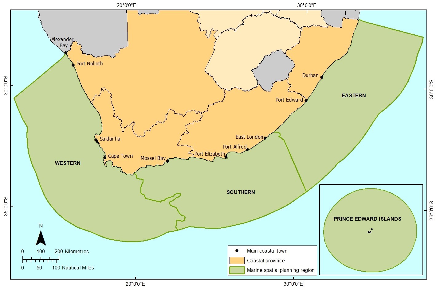
Map 1: The four Marine Planning Areas of South Africa
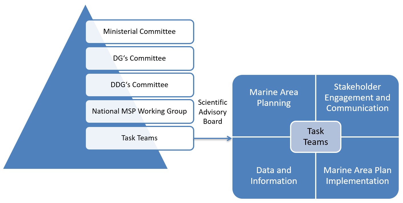
Structures responsible for MSP in South Africa
The lead authority for MSP in South Africa is the Department for Environment, Forestry and Fisheries (DEFF). As lead authority the Department chairs the National Working Group, comprised of competent officials who are nominated from the departments responsible for defence, energy, environmental affairs, fisheries, mineral resources, planning monitoring and evaluation, public enterprises, science and technology, telecommunications, tourism, transport, rural development and land affairs.
The established Directors-General Committee and Ministerial Committee on Marine Spatial Planning are comprised of the aforementioned departments. While the MSP authority DEFF chairs the committees, the Department for Planning Monitoring and Evaluation (DPME) is the co-chair of both committees.
MSP Structures
Status of MSP in South Africa
The process of MSP in South Africa has so far entailed the following key steps:
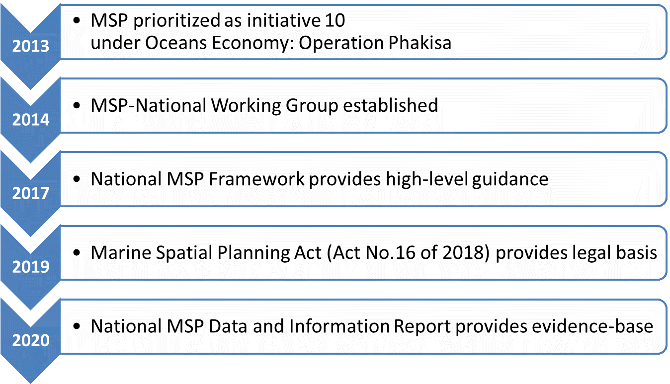
Marine Spatial Planning Act (Act No. 16 of 2018) provides the legal basis for marine spatial planning in South Africa.
The National Framework on Marine Spatial Planning in South Africa provides guidance on MSP on the national level. It specifies the objectives of MSP and outlines the process.
- Link to draft National Framework download (to be revised under inclusion of Spatial Management System)
- Link to draft Spatial Management System download (to be included into the revised National Framework)
The National Data and Information Report (NDIR) for Marine Spatial Planning provides the evidence base and knowledge collated by the National Working Group. It collects the spatial layers that are needed to embark on spatial planning.
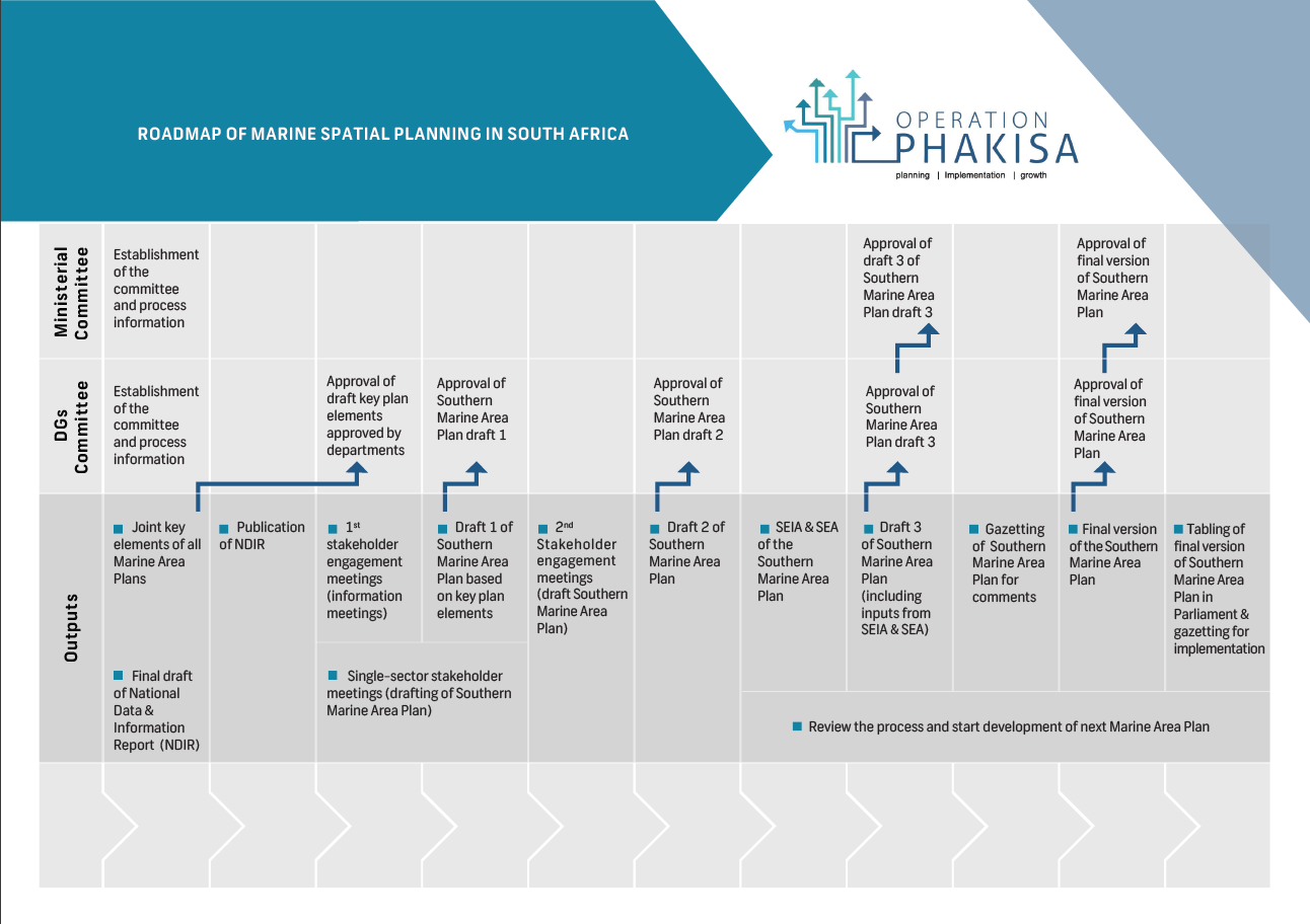
The NWG is currently busy identifying the spatial priorities and claims of each sector and marine activity. On this basis, integrated marine area plans will be drafted. The process of development of the marine area plans is illustrated in the following visualization:
Participation of stakeholders in the process
In the development of the marine spatial planning framework and the marine area plans, the National Working Group must ensure that all relevant stakeholders are adequately consulted (MSP Act 2018, Section 8).
To this end it is planned to have various stakeholder engagement meetings for governmental as well as non-governmental stakeholders. Due to the ongoing COVID-19 pandemic contact meetings have been postponed until further notice. In the meantime, the National Working Group is preparing a virtual stakeholder engagement process, to be commenced in 2021.
To be able to engage with any interested party the MSP secretariat compiles a stakeholder list. Please register yourself as stakeholder HERE.
- Register yourself as a stakeholder (mailing list)
- Comment function for draft plan feedback? à is this possible in the Operation Phakisa website environment?
Key Documents & Reports (& Plans)
PPT – Marine Spatial Planning in South Africa
Video – “Marine Spatial Planning (MSP) in a nutshell" in English, isiZulu and isiXhosa
MSP Act
National Framework (draft)
Spatial Management System (draft)
National Data and Information Report
OCIMS Marine Spatial Planning Support Viewer (link)
Operation Phakisa (link)
Contact & Disclaimer
For more information please contact:
Moses Ramakulukusha
MSP Secretariat
Ocean Conservation Strategies
Department of Environment, Forestry and Fisheries
Tel: 021 819 2494
Mobile: 067 8270 410
Email: MRamakulukusha@environment.gov.za
Address: 1 East pier road, East pier Building, Waterfront, Cape Town, 8001